
Hunters can improve their chances and their backcountry experience with a range of new digital apps. But are there pitfalls?
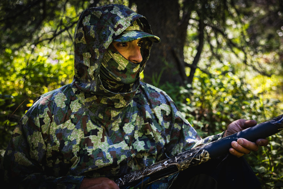
The night before opener on an over-the-counter Colorado archery elk season tag last year, two hunters beelined six miles up a high ridge to a 12,000-foot basin. This cirque holds consistent populations of deer and elk, but it’s generally overlooked by hunters because of the rugged approach and the way it’s largely hemmed in by private boundaries. The two men, brothers from Ohio, had never been to Colorado before—in fact, they’d never hunted elk—but they arrived at this spot based on weeks of online scouting. They’d read the entire Elk 101 series, watched countless video tutorials, and uploaded a route and waypoints to their phones that lead them directly to this little honey hole.
Hunting, which for decades has been long on traditions but short on technological advancement, is going through a sea change in this digital age. Brands such as FORLOH are building high-tech apparel that’s making it easier and more comfortable for hunters to take on the elements. Optics companies are developing products that take the guesswork out of shooting, such as Garmin’s Xero series bow sights that calculate angle-compensated range, drops, and focusing points. And information technology companies, including GoHunt and onXmaps, are transforming the way we prepare for hunts and move through the backcountry with a range of online resources and offline maps.
“The idea for goHUNT started in 2013 with the realization that there was a complete lack of a convenient way for hunters to research and plan for hunts with filterable data to accommodate their personal needs,” says founder and CEO Lorenzo Sartini in introducing goHUNT. “Our mission was to use cutting-edge technology to build a product set that simplifies a hunter’s life.”
The lifeblood of goHUNT is its subscription service, called Insider, that allows users to parse draw data for 13 western states. Using a map-based interface, members can calculate their odds of getting a tag for 26 big-game species based on draw rates, state-by-state modeling projections, historical hunt success rates, and even likely trophy size. For the most part, these data are all publicly available. Similar to the hunt consulting agency The Draw but on a larger scale, goHUNT has waded through the mountains of statistics, crunched thousands of numbers, built an intuitive format, and amassed everything together in one place. Whereas a few years ago a hunter might have spent days or weeks poring over spreadsheets to try and figure out their best odds for hunting in a single state, goHUNT members can now sort through every option in a fraction of the time.
The company’s offerings extend well beyond draw statistics. The website publishes news stories, gear reviews, and incredibly detailed tutorials to help hunters hone their skills. The series on e-scouting, for instance, has made it possible for hunters like the Ohio brothers to take advantage of hunting technology opportunities they might not have previously been able to. And there are timely articles on state-by-state draw deadlines and processes with how to information, insider tips, and links to assist hunters in making their hunt applications.
“We continue to see that nationwide hunter numbers are on the decline,” says Dave Barnett, research manager at goHUNT. “So at the most basic level, our goal has been to simplify and demystify hunting so it’s accessible to more people.”
If goHUNT has changed the way hunters approach and prepare for hunts, onXmaps has done the same—in perhaps even more dramatic fashion—for how hunters get around in the field. Launched in 2009, onX began as the pet project of Montana hunter Eric Siegfried as he tried to figure out an easier way to negotiate the labyrinth of public and private property boundaries in the West. Fed up with the clunkiness and outdated data of paper maps, Siegried began compiling mapping data from a broad range of public sources so that he could carry along up-to-date boundary information on his GPS. The broader his data became, the more friends and acquaintances began asking him for their own copies, and onXmaps was born.
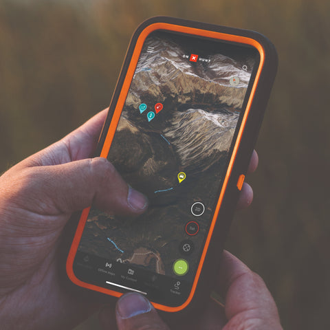
Today, onXmaps is a full nationwide range of high-resolution, satellite-driven maps that’s available to users on a memory card for uploading to a GPS or, more widely these days, as a smart phone app. (It’s worth noting that goHUNT recently launched its own online mapping platform, with plans to add offline capabilities soon.) The app allows users to download maps to the phone directly for use even when there’s no cell coverage. And onX has built an incredible range of tools, including the ability to drop waypoints, measure distances, insert geotagged photos, toggle between topographic, satellite, and even 3D views, and share data between users. The company has also added a suite aimed at backcountry road travel called onXoffroad, and it will soon add live weather data to both apps.
Not only does onXmaps allow for simple, powerful pre-hunt scouting, but the offline capabilities mean hunters know what’s around the next bend or over the next mountain without ever going there. It has taken much of the guesswork out of hunt planning and field navigation.
“Our focus has been helping people feel comfortable when they leave the pavement,” says Zach Sandau, marketing manager at onX. “We want to make it easier for people to get out in the backcountry and maximize their time hunting and not just trying to figure it all out.”
As with any new technology, along with enthusiasm and acceptance onX and goHUNT have also garnered skepticism. Some hunters worry that sharing location data online could lead to long-held hunting grounds becoming exposed or compromised. Sandau points out that, as lifelong sportsmen, everyone at onX is just as cognizant of the need for privacy. He says that the company will never share or sell users data.
Other hunters worry that services like onX and goHUNT will overcrowd the backcountry, drive up demand for already-difficult-to-get tags, and even mar the concept of fair chase by making the hunting experience too easy. “How many advantages do we need?” one hunter asked. Sandau says onXmaps takes all these sorts of concerns to heart, but he feels the benefits outweigh the potential pitfalls. For instance, onX has an entire division, led by Siegfried, devoted to identifying and increasing land access for hunters. The company also produces an informational and inspirational video series on YouTube called “Anyone’s Hunt” that details over-the-counter hunting options available to all sportsmen.
“We know we have made it easier for folks in some respects. Honestly, we feel like it’s a benefit to every hunter if they can spend more time enjoying the experience of hunting,” says Sandau. “But at the end of the day, you still have to do the work. You have to get out in the field and scout, you have to put up that tree stand, and you have to cultivate the skills.”
The Ohio brothers on the elk hunt in Colorado perfectly illustrated Sandau’s point. Though the new hunting technology enabled them to unearth an elk hotbed from afar and easily make their way to it, they saw only one or two animals over a six-day stay and had no close encounters or opportunities. “It was an amazing trip. Such crazy cool country like nothing we have back home,” one said as the pair loaded up to return to Ohio. “The biggest takeaway, however, is how hard elk hunting really is.”